
On this page
Geomap
Overview
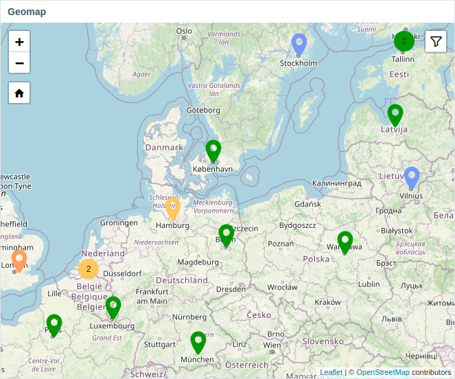
The Geomap widget displays hosts as markers on an interactive Leaflet-based map, with marker colors indicating each host's most severe problem.
Zabbix offers multiple predefined map tile providers and lets you add custom ones in Administration > General > Geographical maps.
By default, the widget displays all enabled hosts that have valid coordinates (latitude -90 to 90, longitude -180 to 180) in their inventory.
Use the following options to interact with the widget:
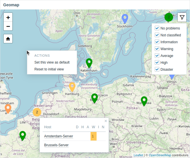
- Clicking a marker shows the host name and unresolved problems; clicking the host name opens the host menu.
- Filter hosts by problem severity using the filter icon in the upper-right corner.
- Right-click the map to set or reset the default view; use the home icon to return to the default view.
Configuration
To add the widget, select Geomap as type.
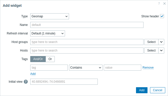
In addition to the parameters that are common for all widgets, you may set the following specific options:
| Host groups | Select host groups to be displayed on the map. Alternatively, select a compatible widget as the data source for host groups. This field is auto-complete, so starting to type the name of a group will offer a dropdown of matching groups. If nothing is selected in both Host groups and Hosts fields, all hosts with valid coordinates will be displayed. This parameter is not available when configuring the widget on a template dashboard. |
| Hosts | Select hosts to be displayed on the map. Alternatively, select a compatible widget or the dashboard as the data source for hosts. This field is auto-complete, so starting to type the name of a host will offer a dropdown of matching hosts. If nothing is selected in both Host groups and Hosts fields, all hosts with valid coordinates will be displayed. This parameter is not available when configuring the widget on a template dashboard. |
| Tags | Specify tags to limit the number of hosts displayed in the widget. It is possible to include as well as exclude specific tags and tag values. Several conditions can be set. Tag name matching is always case-sensitive. There are several operators available for each condition: Exists - include the specified tag names; Equals - include the specified tag names and values (case-sensitive); Contains - include the specified tag names where the tag values contain the entered string (substring match, case-insensitive); Does not exist - exclude the specified tag names; Does not equal - exclude the specified tag names and values (case-sensitive); Does not contain - exclude the specified tag names where the tag values contain the entered string (substring match, case-insensitive). There are two calculation types for conditions: And/Or - all conditions must be met, conditions having the same tag name will be grouped by the Or condition; Or - enough if one condition is met. This parameter is not available when configuring the widget on a template dashboard. |
| Initial view | Comma-separated center coordinates and an optional zoom level to display when the widget is initially loaded in the format <latitude>,<longitude>,<zoom>If initial zoom is specified, the Geomap widget is loaded at the given zoom level. Otherwise, initial zoom is calculated as half of the max zoom for the particular tile provider. The initial view is ignored if the default view is set (see below). Examples: 40.6892494,-74.0466891 40.6892494,-122.0466891 |
| Clustering | Specify how nearby host markers are combined into a single marker with a count: Auto - markers are combined automatically; Zoom level - markers are combined based on the specified zoom level (0 - maximum zoom-out, 30 - maximum zoom-in). For example, if the parameter is set to 0, markers are not combined at any zoom level; if set to 15, markers are combined starting from maximum zoom-out down to zoom level 15; if set to 30, markers are combined at all zoom levels. Note that the maximum zoom-in level is determined by the map tile provider. |